Saturday, May 31, 2014

Moab, Utah

Up fairly early but yesterday was such a long day that we will do a bit of exploring with the truck today. First stop, of course, will be to update our blog as the last campground and this one have had terrible internet connections. Thank goodness for all of the McDonald's across North America and their awesome free WiFi!

Well we were thinking yesterday that we had seen the most amazing things in Utah and she surprised us again. Today we drove through Arches National Park and it took our breath away. 


They name the rocks and arches here; for example:
The three gossips
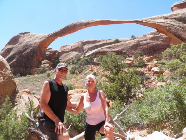
Landscape Arch
Man holding up Landscape Arch
The courthouse
Broken Arch (yes, that's me on the rock)
Delicate Arch (no, that's not me on the rock)

And here are a few that Richard named:

Cinnamon bun
Four Big Macs. 
A cookie

Notice that they all refer to food. I think he's getting hungry. 


Too many beautiful pictures to include. The weather is now at 34 degrees Celsius and still climbing. 


Lunch at McStiffs in Moab. Lots of Utah draft micro brews. We finished lunch at 4:00 so I'm thinking this qualifies for dinner. 

Of course I couldn't help seeking out the local thrift shop where I just keep adding to my wardrobe. A shirt, a cute little dress and a pair of shorts for Richard. It doesn't get much better than this. 

Just sitting here in our favorite WiFi place now having a cream cone so may as well post today's blog😎


Driving Highway 95 in Southern Utah

We are on the road this morning by 9:00. We are headed for Moab but I think the drive will be much longer than the 4 hours it's supposed to take on the route we have decided on. We will drive highway 95 down from 24 which is another scenic drive. Every turn in the road offers a new photographic moment. 
Just the start of our day. 

Our first stop is Capital Reef National Park and we pull in just in time for a presentation by a park ranger on the unique geology that comprises this beautiful area. We were told that July, August and September are the monsoon months and that even 1/4 inch of rain can cause a flash flood. 


The rock changes from red to grey as we proceed along. The hills look like a giant gravel pit or the skin of an elephant. 

At Hanksville we leave 24 and start down highway 95. The land opens up to a vast semi arid plateau to the east and the Henry Mountains rising up to the west. 

In not too long we are back in red rock country. We stop at a rest area called Hog Canyon for lunch. Very relaxing with hardly anyone around. 


My battery on the camera has gone dead once again and it's only noon. Thank goodness for my trusty iPad. 

We stopped at Hite which is a state park, I believe, but is also a marina. Weirdest place I've ever seen. There is an unmanned ranger station, a general store that has a ton of fishing equipment, some great big boats parked nearby, a couple of big boat launches and the most amazing fish cleaning station equipped with a grinder for disposing of the fish carcasses. The only problem is, is that there is no water. Lake Powell has not risen up to that point since 2000. Apparently their website still talks about fishing and all the signs talk about water safety, but NO water access at all. As we walk towards the abandoned launch we pick up a bunch of clam shells which are strewn all over the place. There obviously was water there. 


Drove in to Natural Bridges National Monument and watched a video but we moved on without doing the loop road. It's getting late and we planned on getting to Moab yet tonight. 


We finally arrive in Moab and find our new home at Slickrock RV and Campground; tired but so filled with the images from our drive today that all we can do is light a fire and roast some weanies.
The campsite is so narrow that we occupy 2 sites. 

Grand Staircase - Escalante National Monument drive

Well here we are almost 4 weeks into our trip, May 29, 2014.  I can't believe we've been gone for over 3 weeks. In some ways it feels like we have been gone forever and at the same time we've just left. We've seen so much; so many miles.  This part of Southern Utah is spectacular!  

It's endless. 

These signs mark the way along highway 12 showing the path that the pioneers took. 


Our first stop is Escalante Petrified Forest State Park. They have a short 1 mile hike up into a Pygmy forest that has a large amount of petrified tree specimens. The walk is signposted with descriptions of the flora of the area. We overlook the reservoir far below. Another amazing stop. 

These were fine specimens of a Pygmy Juniper and Pine tree. 


The largest piece of petrified wood on the trail. 

Lots of small pieces as well. 

A great path. 


All was going wonderfully until we stopped for fuel in Escalante and then pulled a tail light off the back end of a 1998 Dodge Ram 1500 with the ass end of our trailer. Oops🙀. A $50 bill fixed the problem and we were on our way.

I believe we are travelling through the Grand Staircase - Escalante for the entire drive. It's incredible!  We stop at a little cafe in the middle of nowhere called Kivi Koffeehouse where we share a ham sandwich and a couple of cookies. It's amazingly busy. It's built right into the side of the mountain. 

The view from our table. 

In Boulder we stop at the Anasazi State Park Museum where we get an idea of the history of the area and how the Hopi Indians migrated there from the south leaving behind many artifacts and archeological finds. Interesting. 
An example of a typical Anasazi village. 

And now we must climb the Boulder Mountains on our quest to complete our drive of National Scenic Byway 12 - An All-American Road. Only a few National Scenic Byways achieve the status of All-American Roads, making Byway 12 one of the most unique roads in the United States. 
Up atop the Boulder Mountains. 

Beautiful Aspens. 


Another view from the top. 


We have taken a campsite at 1000 Lakes RV and Campground in Torrey on highway 24. Tomorrow we will continue our adventure in this beautiful part of Southern Utah. 
A view from our campsite. 

The resident moth. Isn't he georgeous??

Wednesday, May 28, 2014

Bryce Canyon day 2

After we find out that we can stay another night at our current camp spot, we finish up all of our dirty laundry and head out for some serious hiking. Today we will conquer the Navaho Trail. 

The descent is immediate and intense with switchbacks all the way down to the canyon floor.  You really have to visit this amazing part of the world to understand the sheer magnitude of it's vistas.This particular hike will take us 2.6 miles down, through and then back up out of the canyon.
The descent down Navaho Trail

Just one of the many passageways carved out by man. 

One of the many photo ops. 

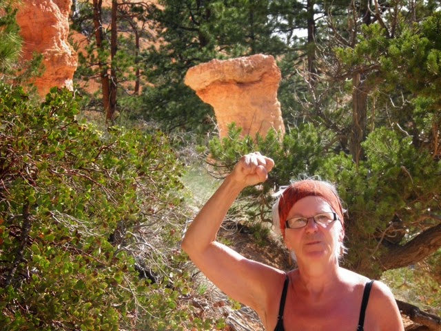
Reminded me of a fist bump. 

You can see how up close and personal you can be in this area. 

We hike along the rim back to where we have parked our truck at Sunset Point. From there we drive to Inspiration Point where you see the most breathtaking views. We hike again on the Rim Trail to Bryce Point travelling along the edge of the canyon. My fear is getting a little better. From there we must hop on to the shuttle to take us back to our truck. This has been the most amazing morning that I won't forget for a long, long time. 

The drive in to Fairyland Canyon affords us the opportunity to "salvage" (steal) some wood for our fire tonight. Someone has bucked up a tree and my good man is not going to miss an opportunity like this.  We stop and grab a few rounds of lovely dry wood🙈🙉🙊
He'd have taken bigger if he could have lifted them. 

We stop at a recommended restaurant for some lunch before coming home to our sweet little trailer for a much deserved rest. 

We're out again by 3:00 to explore the Mossy Cave and waterfall along Tropic Ditch; a canal of water that was dug and diverted by early Morman pioneers to this area in an effort to irrigate their settlements. To this day, the water flows, providing much needed water to Tropic and Cannonville. The only time it has dried up was in 2002 during a drought. 

Now I really want to see Kodachrome Basin State Park, aptly named because of the film used in cameras back in the day.  As we approach the turnoff to the park (which, by the way, is out in the middle of nowhere) we see a sign to Grosvenor Arch so we head down the red dirt road with no idea where we are going. Other than that first sign, we see no other indication that we are travelling in the right direction. Well finally, after about 15 km we come upon the arch. Wow, it's huge.
Grosvenor Arch

On the way back we turned into Kodachrome but decided the $8 was more than we wanted to spend to see more of the same. 

A quick stop in Tropic for hotdogs and buns (not exactly on our diet, but what the hell) we drove home. We've walked over 20,000 steps today (almost 10 miles).

A welcome fire to end the day. 

Tuesday, May 27, 2014

Bryce Canyon National Park

Up at 7:30 and on the road by 9:00 we are headed in the direction of Bryce Canyon. It's supposed to be a hot one today getting up around 31 Celsius. 

We went first into Panguitch to fuel up and get a few groceries before heading to our next camp spot. I also manage to get some stuff for my sewing room at home. 

You start your drive by going through Red Canyon which is amazing.


We have set up camp at Bryce Canyon Pines Campground.  It's about 6 miles from the park entrance and we hope to stay here for a couple of nights while we visit the canyon.  

Breathtaking doesn't even come close to describing this part of the country. It's absolutely a picture right out of National Geographics. We drive to the furthermost point and then make our way back, stopping at the overlooks along the way.


These are the Bristlecone Pine trees that were not able to survive in this harsh environment

I swear this raven followed us through the whole park.

Some interesting formations zoomed in on....

And then zoomed out......see, right in the middle.

This is the Natural Bridge.

See! Here he is again....


This is the view from Bryce Point.

We will definitely spend another day here but it's getting late and dinner is calling out to us. 


I think this our second real fire.

Another end to a another perfect day.